Planina pod Golico - Krvavka
Starting point: Planina pod Golico (980 m)
| Lat/Lon: | 46,4706°N 14,0599°E |
| |
Time of walking: 2 h
Difficulty: easy pathless terrain
Altitude difference: 804 m
Altitude difference po putu: 804 m
Map: Karavanke - osrednji del 1:50.000
Recommended equipment (summer):
Recommended equipment (winter): ice axe, crampons
Views: 8.165
 | 1 person likes this post |
Access to the starting point:
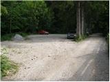
From the motorway Ljubljana - Jesenice take the exit Lipce (or Hrušica) and follow the road in the direction of Jesenice, where signs for Planina pod Golico direct you to the ascending road. The relatively steep road soon leads to the village, where you can admire the daffodils bloming in the surrounding meadows in May. With Mountain pasture under Kahlkogel, drive on to the next crossroads, where you will see a number of mountain signposts. Here, continue right and drive another 50m to the parking lot under the Sava Caves.
Path description:
At the beginning of the parking lot, you will see mountain signs directing you left up the asphalt road. After a short climb, the path leads us to the Betel agritourism farm and beyond to a crossroads where we continue right in the direction of Golice. After a few more minutes of walking along the road, you will reach the hut at Fenec. Pay attention here, as just a few steps further on, a wide marked path branches off to the right, leading to Golica.
The way forward climbs over a short meadow behind which we come to a pleasant shade, after which the path continues. After about half an hour's walk, you will emerge onto a macadam road, which you follow to the right, but only as far as the bottom station of the gods cableway.
From the cable car, continue towards the hut on Kahlkogel along a path that climbs quite steeply through increasingly sparse forest. After a god hour's walk, the path leads us out of the forest and onto the uncultivated slopes from which we can see the hut already in front of us. Just a little further on we come to a crossroads where we continue to the left (Barentaler Kotschna and Markljev and Pusti Rovt on the right). Follow this rather steep path in the last part to the hut.
From the hut, the ascent continues northwards along initially gently sloping and then steep grassy slopes. After a god 20 minutes of ascent, the steepness eases and the path leads us to a crossroads.
Continue right (left Kahlkogel 10 minutes) and climb the easier trackless path to the summit, which you can see in front of you. After about 10 minutes of climbing, you reach the unclimbed summit.

Pictures:
 1
1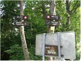 2
2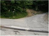 3
3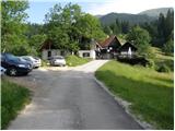 4
4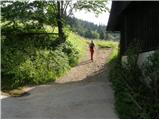 5
5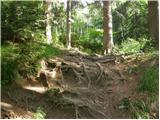 6
6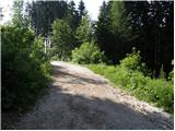 7
7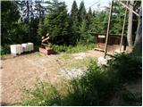 8
8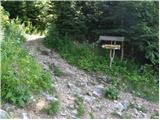 9
9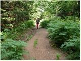 10
10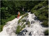 11
11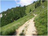 12
12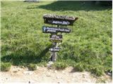 13
13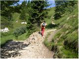 14
14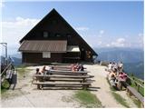 15
15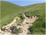 16
16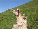 17
17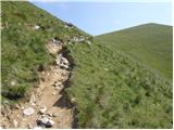 18
18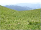 19
19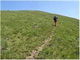 20
20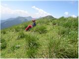 21
21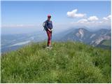 22
22
Discussion about the trail Planina pod Golico - Krvavka
|
| planinec alex2. 10. 2009 |
Obstaja pa tudi pot jesenice-javorniški
rovt.Peljete se do doma Pristave v javorniškem rovtu ter po makadamski
cesti do Suhega sedla kjer parkiramo ,ko pridemo do
spomenika od 2 sv.vojne zagledamo mejni kamen med Republiko slovenijo in avstrijo.Tam je lep razgled na avstrijsko
koroško.Od tam je 7 min.hoje do krvavke
ter 48 min. hoje do golice.
|
|
|
|
| heinz3. 10. 2009 |
planinec alex, tole bo pa žal malo ponesrečen opis..
Sedlo Suha navadno ne služi kot izhodišče, saj nima kakega parkirišča oz prostora za kaj več avtomobilov, zato naj bi bil štart v omenjeno smer najmanj iz Pustega rovta, če že ne od Križovca.
Od sedla- 1439, do Krvavke- 1785, pa nikakor na zadostuje 7 min. hoje, o čemer priča že višinska razlika.. Tako blizu ni niti Mala Golica- 1646, katero si najbrž zamenjal za Krvavko.
Če rečeva, do Krvavke pol, na Golico pa eno uro hoje, sva bližje realnosti, čeprav je za mnoge pohodnike tudi ta ocena preskromna.
|
|
|
|
| Enka3. 10. 2009 |
Šli na Golico spomladi, po poti, ki jo opisuje planinec alex. Na Sedlu Suha je bilo parkirišče za vsaj 10 avtomobilov. Za tiste z manj kondicije, ki ne marajo gužve na klasični poti v času cvetenja narcis, je to odlično izhodišče. Čas hoje je seveda relativna stvar, a vendar - mi ne pokamo od kondicije in smo rabili do Golice več kot uro  .
|
|
|
|
| Enka4. 10. 2009 |
Pozabila sem napisat, da smo šli mi s Pristave do Sedla Suha peš in da so nam šli avtomobili možno na živce, a vendar...
|
|
|
|
| heinz4. 10. 2009 |
Že kmalu na cesti iz Križovca stoji zapornica, malo kasneje pred Pustim rovtom pa še ena, kar priča o tem, da cesta ni namenjena turizmu, ampak potrebam planine in gozdnemu gospodarstvu. Zato, o kakšnem izhodišču na tem mestu ne bi govoril.., saj se mogoče lahko pripeti, da bi bila zapornica nazaj grede zaprta. Ključev pa, kot vemo, nimamo kar vsi.
Za tiste, z manj kondicije, priporočam zgolj "vzpon" od Planine pod golico do Fenca, ali pa do Pristave iz Javornika..
|
|
|