Najdihojca - Lubnik (eastern outside corner)
Starting point: Najdihojca (353 m)
Name of path: eastern outside corner
Time of walking: 1 h 45 min
Difficulty: very difficult pathless terrain
Altitude difference: 672 m
Altitude difference po putu: 702 m
Map:
Recommended equipment (summer): helmet
Recommended equipment (winter): helmet, ice axe, crampons
Views: 4.290
 | 4 people like this post |
Access to the starting point:
We drive to Škofja Loka and on to Podlubnik. Park in a small parking lot under the Najdihojca kindergarten.
Path description:
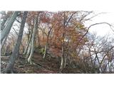
From the parking lot, head to the small bridge over the Selška Sora a few metres away, cross it and turn right just after the bridge onto the path that leads along the riverbed. We are in the area called Vincarje. On your left is first a meadow and then a field, and soon you see a small hydroelectric power station on the opposite bank of the Sora, which you pass. We continue to walk along the path and later along the wider path along the riverbed until we see a direction sign for Lubnik on a tree on the right side of the path, which has been "hugged" by a lot of bark, pointing us up the bank to the left. We go straight ahead. When you get to the Veštr Bridge, don't go over, turn left and stick to this road, walk on the top side of the road until it goes down. Then turn sharply up the bank, the road narrows into a path. The path passes a cave with a spring of water, you come to a meadow (ATTENTION!! It is very overgrown here in summer, thick as in a jungle, so go slowly and carefully until the meadow opens up!). When you cross the meadow, turn left onto the dirt road, make one turn and go in the direction of Praprotna, straight ahead. Take a few steps, when the road starts to descend steeply we turn left into a less visible path, and just after a short climb we turn sharp right, up a bank, onto a trackless path. Cross the road, somewhere the path is a little visible. Here begins an extremely steep climb. Keep going up until you pass boulders and cross the road twice. We are now at 650 m and the trail climbs up to the last road, 773 m. Immediately afterwards, the hard part comes, climbing over boulders, passing some of them. After this part, at about 815 m, a path crosses the trackless road. Keep to the left. We cross an undistinguished, slickened torrent, the bed of which is covered with leaves and at first sight does not look like a torrent at all. After this comes the hard part. The shelves are well led, and we have the aid of a small steel bar (slipping is deadly). When the rope is over, we head straight, into the rocks. We climb over smaller rocks, the world gets steeper and steeper, the smaller rocks are replaced by boulders a little higher up. We go directly over a boulder, II level 8 m. Then we ridge over the rocks a bit and climb over the bigger boulders again, slowly the boulders disappear. We come directly under the hut, see the boulders under the hut and a small cave. Go straight ahead between the nettles and come out at the chapel. A few steps and we are standing on the top of Lubnik. I probably don't need to point out that the route is only for the skilled, all the traversing, climbing over boulders, between boulders is in my opinion a good II to II+ unless you make the world even more difficult. The ravines are also very tricky, slippery and extremely dangerous for slipping, which can be fatal. The route is very steep and exposed from the start, from the Soteska. Already there, the second stage begins. Higher up, after crossing the rocks, it gets even steeper, rockier and more exposed. In the lower part the boulders can be avoided, in the upper part they have to be climbed over. ONLY FOR THE TRAINED, WHO HAVE NO PROBLEMS WITH ORIENTATION AND VERY SLIPPERY, STEEP TERRAIN!!

Pictures:
 1
1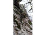 2
2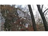 3
3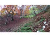 4
4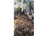 5
5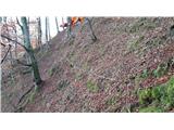 6
6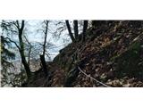 7
7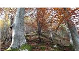 8
8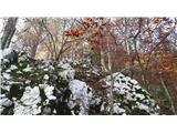 9
9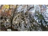 10
10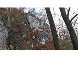 11
11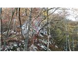 12
12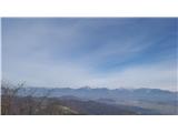 13
13
Discussion about the trail Najdihojca - Lubnik (eastern outside corner)
|
| ranyhyn2. 08. 2021 21:20:39 |
Je prišlo do napake? Sliki 3 in 11 sta namreč identični.
|
|
|
|
| KLAN4. 12. 2021 18:23:24 |
na 11 maš sam označen kje približno gre pot
|
|
|
|
| k1ngju18. 09. 2022 12:28:24 |
haha fajno, dober si to naredu domač trening za vzpone. Bomo sprobal
|
|
|