Most Boka - The Boka waterfall (by bed)
Starting point: Most Boka (400 m)
| Lat/Lon: | 46,3183°N 13,4948°E |
| |
Name of path: by bed
Time of walking: 1 h 15 min
Difficulty: difficult pathless terrain
Altitude difference: 280 m
Altitude difference po putu: 300 m
Map: Julijske Alpe - Zahodni del 1:50.000
Recommended equipment (summer): helmet
Recommended equipment (winter): helmet, ice axe, crampons
Views: 18.992
 | 5 people like this post |
Access to the starting point:
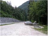
From Bovec, drive to Kobarid or vice versa. There is a parking lot in front of the Boka bridge (from Kobarid, behind the bridge).
Path description:
From the starting point, first walk to the bridge, which opens up a beautiful view of the Boka waterfall. Continue to the other side of the bridge, and from there turn right onto the wide path in the direction of Boka (there are signs for the Boka spring on the other side of the bridge). The path leads you first along a wide path, which quickly splits into two parts. Continue straight on the lower unmarked path (with a viewpoint of the Boka waterfall on the left), which leads to the river after a few minutes. The path on the left side of the river (right bank) initially ascends and then disappears. The Boke then narrows, and steep cliffs block the passages along the riverbed. We continue along a technically slightly more difficult world, as we have to climb from one rock to the other (carefully) in order to progress.
The route of ascent is clear, but the passages are not, and these vary according to the height of the water (the lower the water, the more passages are available). After climbing for some 10 minutes on damp rocks, a beautiful passage opens up on our right. Continue along a relatively steep but less visible path, which leads to larger boulders higher up, which stop the relatively easy passage. Here, at high water level, our route ends.
If the water is relatively low, we find the best passage over the boulders and continue our ascent along the rainy river. Higher up, a difficult passage opens up on the left (it is no longer possible to continue along the riverbed), but it is very exposed to falling rocks. With great care, we climb a step higher and the "path" leads us to slightly less steep slopes with a view of the waterfall on the right. Next, you can climb up the less steep scree to the foot of the cliff (risk of falling rocks) and descend from there right to the waterfall.
The route is both technically and orientationally demanding and is exposed to falling rocks and slipping in most parts.

Pictures:
 1
1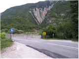 2
2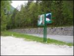 3
3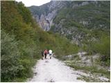 4
4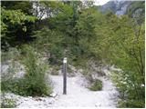 5
5 6
6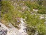 7
7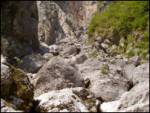 8
8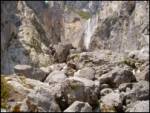 9
9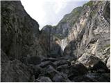 10
10 11
11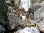 12
12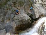 13
13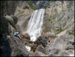 14
14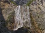 15
15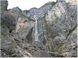 16
16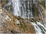 17
17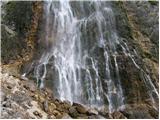 18
18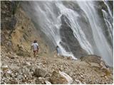 19
19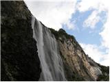 20
20
Discussion about the trail Most Boka - The Boka waterfall (by bed)
|
| Guest6. 11. 2006 |
Vsekakor vredno truda. Je pa potrebno resno jemati količino vode. In samo zahtevnost-ni za vsakogar..
|
|
|
|
| trinity11. 06. 2008 |
Sva bila kak mesec nazaj na razgledni točki, me pa zanima kje je potka za k slapu....do izvira na vrhu slapa...vem da je, ker sva vidla tam ljudi.... kdo ve? 
|
|
|
|
| matejqo10. 09. 2011 |
Niso najbolj jasna navodila, tudi sam sem hotel do izvira, končal pa sem na razgledni točki 
|
|
|
|
| petruša11. 09. 2011 |
Pred mostom moraš iti po stezi, vi pa ste šli za mostom in ste prišli do razgledne točke.lp
|
|
|
|
| matejqo11. 09. 2011 |
Danes sem popravil napako in prišel do izvira ... vreme bilo super, štartal ob 7:55 s parkirišča. Sem se pri izviru na sklali še sončal. Luksuz
|
|
|
|
| planinar_iz_ravnine5. 09. 2015 |
Živjo, že dvakrat sem šel gor po strugi, pa niti enkrat do slapa. Ni mi jasno kje bi naj bi se odprl zahteven prehod. Edina pot, ki se mi je zdela možna, je bila gor po melišču, dalje pa res nimam idej. Bi lahko mogoče nekdo bolj podrobno razložil kje se da prit gor? Hvaležen bi bil za kako fotografijo..
|
|
|
|
| IgorZlodej5. 09. 2015 |
Markirana pot prične na vzhodni strani mostu, ni kaj zgrešiti.
|
|
|
|
| planinar_iz_ravnine6. 09. 2015 |
Ok, zakaj pa v opisu poti piše da se gre po strugi in nekje levo? Vidim pa tudi po slikah da je pristop z leve strani. Markirana pot pa je z desne. V tretje mogoče, kdo ve
|
|
|
|
| IgorZlodej6. 09. 2015 |
Po strugi se gre kadar je slap zamrznjen, do vznožja, potem pa dve bajli pa čez 
|
|
|