Kühtai - Kraspesspitze (zahodni pristop iz Kühtaia in čez sedlo Finstertal)
Starting point: Kühtai (2020 m)
| Lat/Lon: | 47,21371°N 11,02469°E |
| |
Name of path: zahodni pristop iz Kühtaia in čez sedlo Finstertal
Time of walking: 4 h
Difficulty: partly demanding marked way
Altitude difference: 934 m
Altitude difference po putu: 934 m
Map: Stubaier Alpen Sellrain, 31/2 1:25.000
Recommended equipment (summer):
Recommended equipment (winter): ice axe, crampons
Views: 275
 | 5 people like this post |
Access to the starting point:
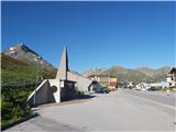
From Ljubljana, take the motorway past Salzburg towards Munich. At the Dreieck Inntal multi-level junction, take the A93 towards Innsbruck/Kufstein/Brenner. On your return to Austria, continue on the A12 motorway to the junction with exit 87-Zirl-Ost. There, join the L13 and follow it into the Sellraine valley. The wide and comfortable road continues past Sellrain, Gries and St. Sigmund and through a long tunnel, after which, after about 20 km of moderate climbing, we find ourselves in the tourist hamlet of Kühtai. The best parking is free of charge at the chapel and bus stop just after the signpost marking the start of the village, but as long as it is busy, the hamlet offers a number of alternatives. It is also possible to drive through the village and start the climb at the Dortmunder Hütte, in which case there is a slightly higher altitude difference but a slightly more direct route to the Finstertal reservoir.
An alternative is to drive through northern Itali: in this case, from central Slovenia, take the A2 motorway to one of the border crossings with Austria and continue to Lienz. Here you continue on the 100 road and pass the Prato alla Drava crossing into Itali. In Itali, follow the SS49 all the way to the junction with the A22 motorway in the direction of the Brenner Pass. After the pass, continue in the direction of Innsbruck and then a few kilometres in the direction of Bregenz to exit 87-Zirl-Ost. From there, follow the directions given above.
Path description:
Just above the high mountain chapel in the eastern part of Kühtai, a signpost points west towards Sulzkogl and the Finstertal reservoir. After a few minutes of easy crossing above Kühtai, the trail turns south and begins to descend gently towards a plain about 50 metres below the starting point, from which you can see the continuation of the trail towards the viewpoint over the lake, located to the left of the barrier above us. The path, which is soon joined by the path coming from the route of the Dortmunder Hütte, continues for some time on a moderate ascent up a grassy slope, crossing torrents on several occasions. A little higher up, we cross the mountain road a few times and, after a good hour's walk from the starting point above the tunnel, we climb up to a lookout point above the northern edge of the reservoir, where there is a large panoramic signboard and a fine view of the Zwölferkogel massif, which obscures the Sulzkogel behind it.
The path continues along a mainly horizontal slope to the left above the lake (or rather above the depression in which it was located) and, after a leisurely walk of just over half an hour, leads to the southern edge of the lake, below the rock building of the Finstertaler Schartenkopf (Finstertaler Schartenkopf). At the end of the crossing above the lake, at the signpost, follow the signs for Finstertaler Scharte and turn sharp left (straight ahead - westwards - the path leads to Sulzkogl).
After the crossroads, we climb moderately steeply up a grassy slope in a meandering manner to the plain between the lake and the Finstertal saddle, where we have a fine view of the Kraspesspitze ahead, but also a wonderful view back towards Sulzkogl and Zwölferkogl. After a short, gentle climb straight southwards, we turn right at the foot of the slope leading to the Finstertaler Scharte and start a slightly steeper climb along the western edge of the high mountain valley. The route continues up the eastern slope of the Schartenkopf, then crosses over the upper edge of the valley, which remains snow-covered for most of the year, and ascends via a fairly steep (partly difficult) jump to the level ground just below the Finstertaler Scharte, which is only a short walk away. From the saddle, continue to the left eastwards towards Kraspesspitze (straight ahead - to the south - is the path to the Schweinfurter Hütte, to the right - to the west - can be traced a less well-marked path leading to the Schartenkopf, which takes about 15 minutes to reach from the saddle, with a slight climb (I)). The trail to Kraspesspitze, before the start of its western ridge, gives way to the vast southern slopes below and descends initially about 30 metres, but after a short traverse on the flat it rises steeply over a grassy hollow, where we climb over some easy short rocky jumps (partly difficult). When we reach the flat above the slope, the markers direct us to the left to cross below the Kraspesspitze ridge on a track that climbs gently towards the summit, now visible in front of us. A little higher up, the track splits, allowing us to cross part of the fairly wide ridge or to continue below it. There is a somewhat uncomfortable scramble over rubble with large jagged stones and we find ourselves at a signpost below the summit, where we join a slightly flatter path leading from the route of the Schweinfurter Hütte.
In the last part of the trail, we climb moderately steeply on rocky terrain to the broad southern ridge, which leads us in a few minutes to the lookout summit with a large cross and a signing book.
Although the ascent is over snow-covered slopes for most of the year, winter equipment is not usually needed from early summer onwards, except in the case of icy slopes below the Finstertal (e. g. in the early hours of early summer or late autumn). In any case, it is important to check the current conditions before ascending. If you have a long day and are fit enough, you can combine the hike with ascents of other peaks that rise above the Küchtai (e. g. Sulzkogel, Pockkogel or Neunerkogel). Along the way, you can climb from the Finsterstal saddle in a quarter of an hour, over slightly more difficult terrain, to the Finstertaler Schartenkopf, which offers a fine view of the Kraspesspitze and the other mountains that form a ring above the Finstertal reservoir.

Pictures:
 1
1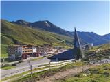 2
2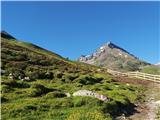 3
3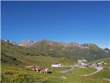 4
4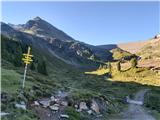 5
5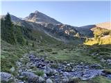 6
6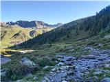 7
7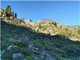 8
8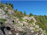 9
9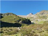 10
10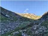 11
11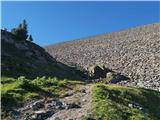 12
12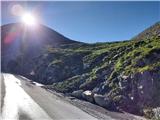 13
13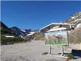 14
14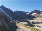 15
15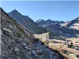 16
16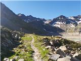 17
17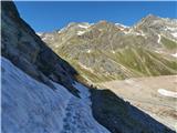 18
18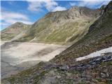 19
19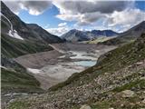 20
20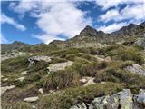 21
21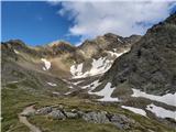 22
22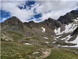 23
23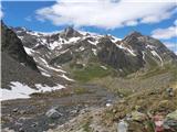 24
24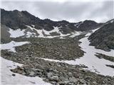 25
25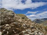 26
26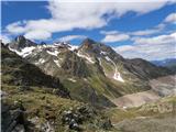 27
27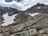 28
28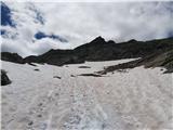 29
29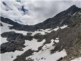 30
30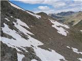 31
31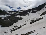 32
32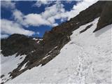 33
33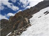 34
34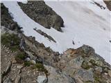 35
35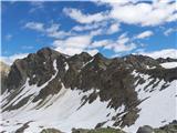 36
36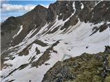 37
37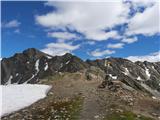 38
38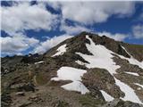 39
39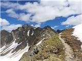 40
40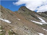 41
41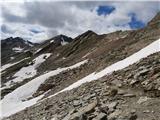 42
42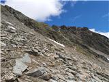 43
43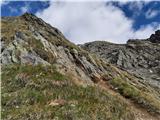 44
44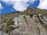 45
45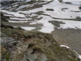 46
46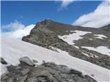 47
47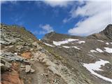 48
48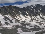 49
49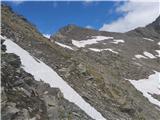 50
50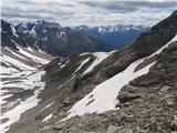 51
51 52
52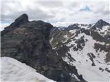 53
53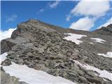 54
54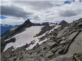 55
55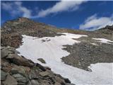 56
56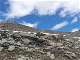 57
57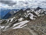 58
58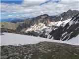 59
59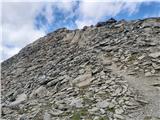 60
60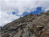 61
61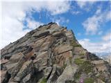 62
62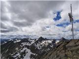 63
63
Discussion about the trail Kühtai - Kraspesspitze (zahodni pristop iz Kühtaia in čez sedlo Finstertal)