Krma - Tosc (northern approach from Bohinjska vratca)
Starting point: Krma (946 m)
Name of path: northern approach from Bohinjska vratca
Time of walking: 5 h
Difficulty: partly demanding marked way, very difficult pathless terrain
Altitude difference: 1329 m
Altitude difference po putu: 1330 m
Map: Triglav 1:25000
Recommended equipment (summer): helmet
Recommended equipment (winter): helmet, ice axe, crampons
Views: 3.140
 | 11 people like this post |
Access to the starting point:
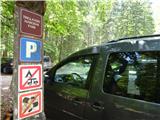
From Mojstrana in Gorenjska, drive into the Krma valley, where you turn onto the forest road towards Kovinarska Koča, and from there continue to the end of the road to the Pri Lesi parking lot, where there are signs for the Triglav National Park.
Path description:
At the end of the forest road, or from the parking lot at Lesa, we start our journey, initially on a gently sloping road. The faint road continues for a while over small gravel areas, then begins to rise slightly and turns into a rocky cart track. After crossing a slightly larger torrent, the path begins to climb steeply through more dense forest. Higher up, the path leaves the forest and becomes lane of dwarf pines, mixed with scrub, and over the above slope climbs over rubble, with larger rocks interspersed. After less than an hour's walk, somewhere at a height of about 1400 m, the path lays down again and leads to a beautiful grassy plain called Vrtača. On the other side of the plain, the path begins to climb again and after about 15 minutes of further walking leads us to Malo polje, where along the path in the middle of the plain between the larger boulders we see a crossroads, where there are often cairns, but apart from the faded inscriptions and markings, there are no other markings for the Bohinjska vratca or Vodnikov dom, unfortunately, as the main marked path here onwards leads towards Triglav.
Continue along the tiny path to the left in the direction of Bohinjska vratce and Vodnik's home. The slightly sloping and poorly marked path begins to climb gradually, first through a sparse larch forest, and then leads to a wide scree slope. The path up the scree becomes steeper and steeper and winds in many switchbacks towards the saddle between Vernar and Tosec - called Bohinjska vratca. The last part of the path below the saddle is steeper and rougher, and the proximity of the vertical walls below Vernar increases the risk of falling rocks.
From Bohinjska vratace turn left (Vernar to the right, Vodnikom dom down), towards the imposing Tosc wall with its wide and stepped thresholds. After only a few dozen metres we reach the quite difficult and steep entry of about 8 m chimney (I-II), which fortunately has enough steps and handholds to be successfully negotiated. Anyone who has too much difficulty climbing here is advised not to proceed further, as there are at least two other such more difficult places on the ascent, when it is necessary to climb over a shorter rock step or rock threshold.
The easiest ascent - in the most optimal direction - is a kind of triple curve: up over the first chimney, left, over a rock ledge, right, over a rock ledge, left, over a rock step and then across to the right over three small scree tongues and finally left for the last time over a shallow and rough ridge all the way up to the top greens (see picture). A few cairns are always placed, but sometimes unfortunately they are not really in the right places, so it is always necessary to look in advance to choose the best direction rather than just follow them.
Generally speaking, the rock grade to the left is steeper and more difficult to climb, and to the right - looking up - less steep, but the terrain is more slippery and lumpy, constantly running and slipping underfoot, so the risk of falling rocks is high, especially for those climbing behind us. So we make good use of the few green cross lanes in between to look for drawbridges upwards. The passages over rock steps or thresholds in the second half or further on are no longer too difficult and, with a good choice of direction, do not exceed the difficulty of the first entry chimney, but for those less experienced in climbing skills and orientation, it is recommended to be accompanied by a guide and the occasional belaying, generally when crossing a more difficult threshold.
The descent from the top of Tosc is usually done by the normal approach and the marked path leading to it from the south side, but this path around to Vodnik's home and then back to Bohinjske vratace - if you are returning to Krma - is quite long and very hot in summer.

Pictures:
 1
1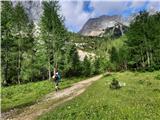 2
2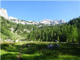 3
3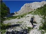 4
4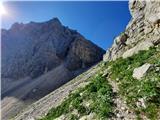 5
5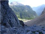 6
6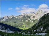 7
7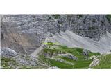 8
8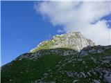 9
9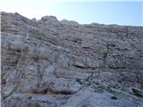 10
10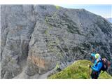 11
11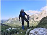 12
12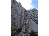 13
13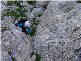 14
14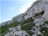 15
15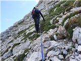 16
16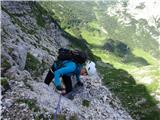 17
17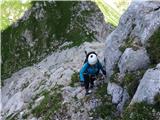 18
18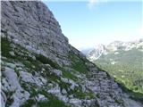 19
19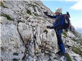 20
20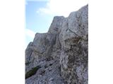 21
21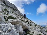 22
22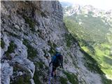 23
23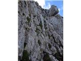 24
24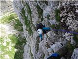 25
25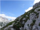 26
26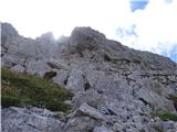 27
27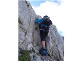 28
28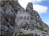 29
29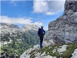 30
30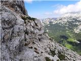 31
31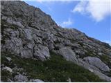 32
32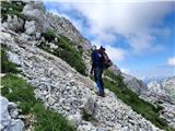 33
33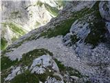 34
34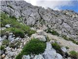 35
35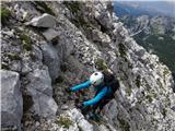 36
36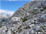 37
37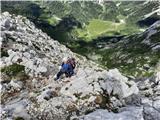 38
38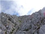 39
39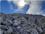 40
40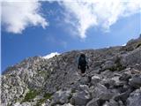 41
41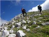 42
42 43
43 44
44
Discussion about the trail Krma - Tosc (northern approach from Bohinjska vratca)
|
| dprapr22. 08. 2022 19:19:26 |
Moje prvo brezpotje, v sestopu. V najstniških letih. Trije smo bili, najmlajši 16 let. Smo rekli, saj tu dol bo šlo, pa še bližje je do doline Voje. Pa je šlo, brez kakšnih težav z orientacijo. Smo opravljali turo od Stare Fužine, preko Uskovnice, Tosca, Kanjavca, L. Špičja, Komne, Bogatina, do Krna in nazaj v Bohinj do cerkve. Se nismo spraševali, kje bi parkirali in za koliko. 
|
|
|
|
| Daaam22. 08. 2022 19:38:02 |
Moje prvo brezpotje, ki sem ga šel sam in po vodniku povohaš dvojko. In ker seveda jaz nisem Drago sem sestopal po normalki. Ponovil turo še dvakrat ( na zadnje se je kolegici pod nogami odtrgala ogromna skala jaz spodaj in za cca pol metra sem bil izven linije) tam malo nad drugim kaminom. Kocine so mi šle po konci ko se je gmota valila po pobočju, kolegica me je pa že videla pod cipresami. Na poti domov smo enega zvrnili čez rame da smo pomirili bogove  opozorilo o proženju je še kako na mestu 
|
|
|
|
| ppegan23. 08. 2022 08:52:03 |
Alyas, hvala za opis, bo prišel prav Koliko časa približno pa se hodi/pleza z Bohinjskih vratc do vrha? Eno uro?
|
|
|
|
| alyas23. 08. 2022 09:44:05 |
ja, ko greš prvič - ko se rabiš malo orientirati in razgledovati naokoli, bo raje bližje dvema urama kot pa eni, sicer pa je 1.30 kar realen čas za navzgor.
|
|
|
|
| ppegan23. 08. 2022 10:49:20 |
Ok. Hvala
|
|
|
|
| ljubitelj gora24. 08. 2022 12:30:47 |
Men je blo boljš iz Pokljuke, za Vernar iz Krme.
|
|
|
|
| BorStenar20. 11. 2022 11:12:48 |
Hoj
je kaj tehničnih težav, če greš samo do Bohinjskih vratc? kakšna oprema je potrebna le do tja?
LP hvala
|
|
|
|
| Janez Seliškar20. 11. 2022 12:40:04 |
BorStenar, ko boš pogledal na planinsko karto, boš videl, da preko Bohinjskih vratc vodi označena planinska pot! Torej, poglej in preberi si vse o tej poti.
|
|
|
|
| madeira24. 11. 2022 07:42:46 |
Na planinskih kartah je pot iz Krme do Bohinjskih vratc res označena kot markirana, ampak v resnici ni več. Tudi odcep proti bohinjskim vratcem je označen samo z možicem. Na poti do vratc je mogoče vidna kakšna prastara markacija, drugače pa je pot označena z možici. Na drugi strani bohinjskih vratc do Vodnikovega doma pa ni problema z markacijami.
|
|
|
|
| docepe224. 11. 2022 10:01:15 |
To sem jaz PZS poleti opozoril in so mi odgovorili, da bodo obvestili skrbnika. Kmalu nato je bil objavljen razpis za novega skrbnika te poti in še nekaj v bližini.
|
|
|
|
| BorStenar24. 11. 2022 20:39:55 |
Torej je pot na Bohinjska Vratca od velega polja markirana za Krmo, iz Krme pa je pot tja označena samo z možici...
|
|
|