Kriška planina - Košutna (via planina Košutna)
Starting point: Kriška planina (1480 m)
| Lat/Lon: | 46,2929°N 14,5369°E |
| |
Name of path: via planina Košutna
Time of walking: 2 h 5 min
Difficulty: partly demanding marked way
Altitude difference: 494 m
Altitude difference po putu: 600 m
Map: Kamniške in Savinjske Alpe 1:50.000
Recommended equipment (summer): helmet
Recommended equipment (winter): helmet, ice axe, crampons
Views: 26.365
 | 4 people like this post |
Access to the starting point:
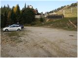
a) From the motorway Ljubljana - Jesenice take the exit Vodice, then continue to the first semaphore crossing in Vodice, where you turn left towards Cerkelj na Gorenjskem and Brnik. When you reach the main roundabout at Spodnji Brnik, continue driving in the direction of Cerkeliai and the ski resort Krvavec. At the end of Cerklje na Gorenjskem, leave the main road, which continues towards Velesovo and Visoke, and turn slightly right onto the road towards the ski resort Krvavec. Continue to the village of Grad, where signs for Ambrož pod Krvavcem direct you to the right on a steep asphalt road (straight ahead to the lower station of the round-cabin cable car to Krvavec and Štefanja Gora). When the steepness of the steep road eases slightly, you will come to a junction, where you will continue to the left in the direction of Ambrož pod Krvavcem (straight ahead to the settlements of Ravne, Apno and Šenturška Gora). A little further on, the road descends a little and then climbs over slopes that are sometimes quite scenic. Higher up, you reach Ambrož pod Krvavcem, where you pass the church of St Ambrose and the tourist farm Pr Ambružarju on the left. From the tourist farm the road passes into the forest and climbs through it to mountain pasture Jezerec, where there is a large parking lot. The road is laid here and turns left, about 500 m further on it leads to a crossroads, where you continue right in the direction of Kriška planina (straight ahead the upper station of the round-cabin cableway and the Mountain Home at Gospinac). There is only a short steep climb and you arrive at a parking lot at the edge of Kriška planina.
The road from mountain pasture Jezerec to Kriška planina is now closed to public traffic, which extends the journey by about 15 minutes.
b) From the motorway Jesenice - Ljubljana take the exit Kranj - East, then continue to Brnik, Komenda and Mengeš. Once you reach the main roundabout at Spodnji Brnik, continue driving towards Cerkeliai and the ski resort Krvavec. At the end of Cerklje na Gorenjskem, leave the main road, which continues towards Velesovo and Visoke, and turn slightly right onto the road towards the ski resort Krvavec. Continue to the village of Grad, where the signs for Ambrož pod Krvavcem direct you to the right on a steep asphalt road (straight ahead to the lower station of the circular cable car to Krvavec and Štefanja Gora). When the steepness of the steep road eases slightly, you will come to a crossroads, where you will continue to the left in the direction of Ambrož pod Krvavcem (straight ahead to the settlements of Ravne, Apno and Šenturška Gora). A little further on, the road descends a little and then climbs over slopes that are sometimes quite scenic. Higher up, you reach Ambrož pod Krvavcem, where you pass the church of St Ambrose and the tourist farm Pr Ambružarju on the left. From the tourist farm the road passes into the forest and climbs through it to mountain pasture Jezerec, where there is a large parking lot. The road is laid here and turns left, about 500 m further on it leads to a crossroads, where you continue right in the direction of Kriška planina (straight ahead the upper station of the round-cabin cableway and the Mountain Home at Gospinec). There is only a short steep climb and you arrive at a parking area at the edge of Kriška planina. The road from mountain pasture Jezerec to Kriška planina is now closed to public traffic, which extends the journey by about 15 minutes.
Path description:
From the parking lot, turn onto the road in the route mountain pasture Koren. The road then leads through an underpass to a quarry, where you leave. Continue the ascent along a pleasant but poorly visible mountain path, which runs along the edge of the pasture fence. The path, which becomes more visible, then leaves the Kriška planina grazing areas and enters a world covered with dwarf pines. After a short climb, the path leads to a beautiful viewpoint, from which we have a beautiful view of the Korošica valley. Next, the path starts to descend more steeply and after a few minutes we are already 60m lower. The path then flattens out and we are joined on the right by the path from the valley mentioned above. Next we cross the lane of a forest, and then the path starts to climb again. During the ascent, an unmarked path branches off to the left, leading to the Razor saddle, and we continue on the marked path, which after a few minutes leads us to the southern part of the mountain pasture Koren. The path then descends past the animal watering point to the shepherd's hut at mountain pasture.
Here, at the hut, a path branches off slightly to the right (south-easterly direction) and leads to mountain pasture Košutna. The path initially crosses the slopes almost horizontally and then leads to a technically difficult place. The path climbs steeply over a short rock jump, where fixed safety gear is helpful. The path then lays down and leads us past the cross to mountain pasture Košutna, where the chapel and shepherd's hut stand.
From mountain pasture, follow the less well-trodden path which passes to the left of the chapel between dwarf pines. The path continues gently up the moderately steep and scenic slope Košutna. When the path is fully level, a path branches off to the right to the top of Košutna (the branch is marked, but the path is incorrectly marked). Follow this very poorly visible path all the way to the top, which is reached after 15 minutes of further walking (keep to the left-hand crossing, although the marking in the lower part directs you to the right).
The path is marked but in some places difficult to follow. If you lose the path, look for a crossing between dwarf pines, taking care not to get stuck in dwarf pines.
Kriška planina - mountain pasture Rot 1:15, mountain pasture Rot - Košutna 50 minutes.

Pictures:
 1
1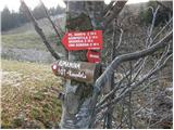 2
2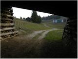 3
3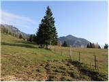 4
4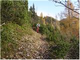 5
5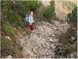 6
6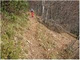 7
7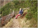 8
8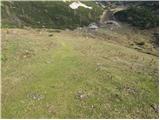 9
9 10
10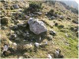 11
11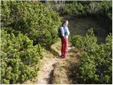 12
12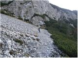 13
13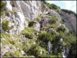 14
14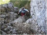 15
15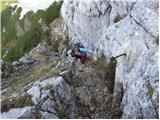 16
16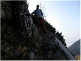 17
17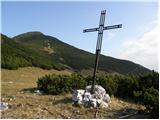 18
18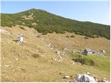 19
19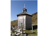 20
20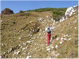 21
21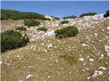 22
22 23
23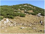 24
24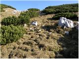 25
25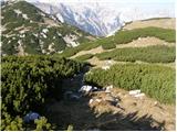 26
26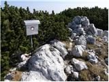 27
27
Discussion about the trail Kriška planina - Košutna (via planina Košutna)
|
| Kriška7. 11. 2008 |
Na tole zanimivo pot imam lep spomin izpred dveh let - do kapelice in pastirske koče na planini sva prišla prav takrat, ko je bilo tam nekaj ljudi, ki so prej imeli v kapelici mašo, potem pa so se malce krepčali pred kočo. Glavno besedo vesele družbe (ki sva se ji za nekaj časa pridružila) je imel zelo simpatičen gospod, ki se ga še vedno rada spomnim - župnik iz Trzina, g. Pavle. Če kdaj bere tele strani - lep pozdrav iz Tržiške okolice in upam še kdaj nasvidenje! 
|
|
|
|
| krsto7127. 11. 2011 |
Lep izlet...Danes ga prehodil po opisani poti, s tem, da sem parkiral na koncu asfalta pred zapornico (Planina Jezerca), sam izlet pa sem podaljšal še na Kompotelo. Markacije na Košutno so očitno popravljene od časa, ko je avtor pisal navedeni opis poti, saj te vodijo direktno po poti med ruševjem na vrh, prav tako je pot dobro vidna in označena. Z vrha Košutne pa sem poiskal pot med ruševjem (stezica je vidno shojena) v smeri Kompotele in prišel direktno pod Kompotelo in si s tem prihranil pol ure hoje po markirani poti. Odličen izlet, ki pa ga je ob vrnitvi malo pokvaril pogled na Kriško planino - razstava pločevine na vseh mogočih lokacijah - dovozih, travnikih...Mogoče bi bilo dobro razmisliti s strani odgovornih, da zapornica na koncu asfalta ostane zaprta (razen za oskrbnike in zaposlene...) in se s tem prepreči množičen "avtomobilski" turizem na omenjeni planini...
|
|
|
|
| ciklama28. 03. 2012 |
Danes sva prehodila opisano pot, ki je na novo markirana in zelo zgledno označena (bravo PD Komenda!). Na nekaterih mestih, sploh višje, je še precej snega in so razmere še kar zimske. Z vrha Košutne sva šla še na Kompotelo in uživala v prekrasnih razgledih na KSA. To je bil čudovit dan za relaksacijo in napolnitev baterij!
|
|
|