Kranj (Kalvarija) - Šmarjetna gora (by road)
Starting point: Kranj (Kalvarija) (390 m)
| Lat/Lon: | 46,2399°N 14,3464°E |
| |
Name of path: by road
Time of walking: 40 min
Difficulty: easy marked way
Altitude difference: 256 m
Altitude difference po putu: 256 m
Map: Škofjeloško in Cerkljansko hribovje 1:50.000
Recommended equipment (summer):
Recommended equipment (winter):
Views: 30.060
 | 4 people like this post |
Access to the starting point:
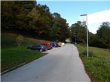
a) From Medvode or Škofja Loka, take the old road to Kranj, then go downhill to the roundabout where the main road takes the first exit to the right and then over the bridge over the Sava River, and we take the second exit in the direction of Besnice and Šmarjetna gora. We pass through an underpass and take a sharp right turn, then at a nearby junction we take a sharp left in the direction of Šmarjetna gora. The road then climbs steeply, then at the next junction we turn right, again in the direction of Šmarjetna gora, and then park in a suitable place on the roadside.
b) From the motorway Ljubljana - Jesenice, take the exit Kranj - East, and then continue in the direction of Škofja Loka at all subsequent junctions. When approaching the underpass where the road to Škofja Loka passes under the old Ljubljana - Kranj road, we continue to the right in the direction of Jesenice and Kranja, and then after a short climb join the above mentioned old road, which we continue along towards Jesenice, and then descend the hill to the roundabout where the main road takes the first exit to the right and then over the bridge over the Sava River, and we continue to the second exit in the direction of Besnice and Šmarjetna gora. We pass through an underpass and take a sharp right turn, then at a nearby junction we take a sharp left in the direction of Šmarjetna gora. The road then climbs steeply, then at the next junction we turn right, again in the direction of Šmarjetna gora, and then park in a suitable place on the side of the road.
c) From the motorway Jesenice - Ljubljana, take the exit Kranj - west, then continue towards Kranj and then Škofja Loka and Ljubljana. After the bridge over the Sava River, at the roundabout take the first exit to the right towards Besnice and Šmarjetna gora. Drive through the underpass and take a sharp right turn, then at the nearby junction take a sharp left in the direction of Šmarjetna gora. The road then climbs steeply and at the next junction bear right again towards Šmarjetna gora and park at a suitable roadside parking place.
Path description:
From the starting point, continue along the asphalt road, which begins to climb up the slope called Kalvarija. The asphalt road, which makes some serpentines and from which we occasionally get some views towards Kranj and the Alps, leads us higher up under a small pass where the path splits.
To the left you can continue on the footpath or higher up the macadam road, while we continue on the asphalt road, which goes from the slopes of Gradišče (592 m) to the slopes of Šmarjetna gora (643 m). We then follow the above-mentioned road, which is entirely asphalted, to the top of Šmarjetna gora, where the Church of St Marjeta and the Bellevue Hotel are situated. From the top, you have a beautiful view of the Alps and Gorenjska.
Description and pictures refer to the situation in 2016 (October).
Pictures:
 1
1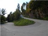 2
2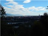 3
3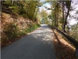 4
4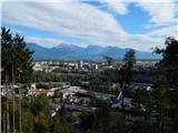 5
5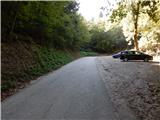 6
6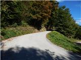 7
7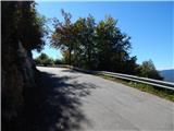 8
8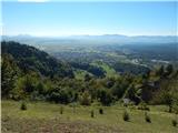 9
9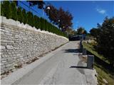 10
10 11
11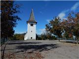 12
12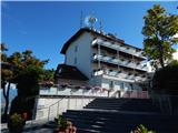 13
13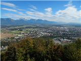 14
14 15
15
Discussion about the trail Kranj (Kalvarija) - Šmarjetna gora (by road)
|
| darh19. 06. 2011 |
Na vrh se je mogoče povzpeti tudi z zahodne strani po mnogo prijetnejši pešpoti skozi gozd. Podrobnejši opis si lahko preberete tule.
|
|
|
|
| navrhu12. 03. 2016 |
Ali ni gor gostinskega lokala? Kateri hrib pa je nad Kranjem, ko gledaš iz Kranja proti JZ, vidiš eno mogočno stavbo na bližnjem hribu. Jutri bi šel tam gor, pa ne vem kako in kje začeti ter kaj je gor.
|
|
|