Starting point: Kocenpohar (785 m)
| Lat/Lon: | 46,2236°N 13,9595°E |
| |
Time of walking: 2 h 45 min
Difficulty: easy marked way
Altitude difference: 1059 m
Altitude difference po putu: 1059 m
Map: Škofjeloško in Cerkljansko hribovje 1:50.000
Recommended equipment (summer):
Recommended equipment (winter): ice axe, crampons
Views: 27.358
 | 2 people like this post |
Access to the starting point:
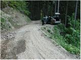
From Tolmin or Škofja Loka, drive to the village of Podbrdo (you can also get there by train or by bus from Bohinjska Bistrica), where the road to the village of Bača branches off in the centre of the village. The asphalted road, which soon becomes very narrow, starts to climb steeply and leads to a crossroads. At the crossroads, turn left on the dirt road, which initially descends and then begins to climb again. The very narrow road leads us to the fence at the Kocenpohar farm. Just in front of the fence is a small parking area for up to two cars, so it is better to park a little lower down.
Path description:
From the parking lot continue along the steep road to the fence which you cross and on the other side you come to a meadow on a farm. Continue along the left-hand side of the farmhouse, continuing along the worse road. Our path crosses the fence again and then descends slightly to a small stream where there is a crossroads of two cart tracks. Take the steep track on the left, which crosses the stream and, after a short climb, leads to a small clearing by a run-down farm.
Next, turn right onto the track which goes into the forest and climbs moderately. "After 15 minutes, Cart track leads from the ruined farm to a forest road. Follow this road as far as Sedlo, where it joins the path from the village Kal (the road has a short cut along a marked path).
At Sedlo, take the path marked for the Black Finger. The initially gentle path soon begins to climb steeply up the steep vegetated western slope. In time, the path leads to an unmarked ridge and continues along the eastern slope. When the path leads us to the ridge again, a beautiful view opens up. There is also a small bench which offers us a well-deserved rest. The way forward goes back into the forest and continues to climb quite steeply. Soon the path approaches a viewpoint just a few steps from the path. Beyond the viewpoint, the path soon passes out of the forest onto the grassy slopes of the Black soil. There are many mountain flowers along the path, which is becoming more and more scenic. However, as we are climbing on steep slopes, it is very tiring to climb in the middle of the day, so it is better to start early. The path becomes slightly less steep and leads us to the saddle Čez suho, where a beautiful view of the Bohinj side opens up.
Here, at the crossroads, turn left and within ten minutes you will reach the home of the Black Prsts. From the hut to the top, where the viewing platform stands, we have only a few steps to go.
Kocenpohar - Sedlo 45 minutes, Sedlo - Črna prst 2:00.

Pictures:
 1
1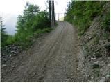 2
2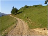 3
3 4
4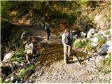 5
5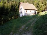 6
6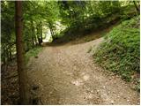 7
7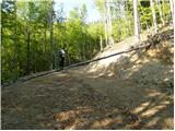 8
8 9
9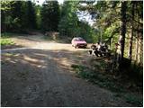 10
10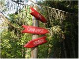 11
11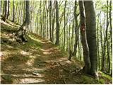 12
12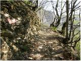 13
13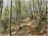 14
14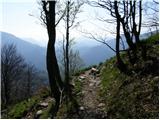 15
15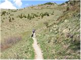 16
16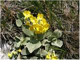 17
17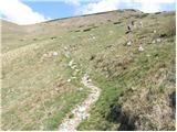 18
18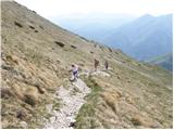 19
19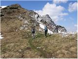 20
20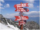 21
21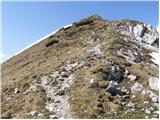 22
22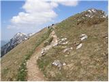 23
23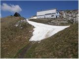 24
24 25
25
Discussion about the trail Kocenpohar - Črna prst
|
| Tadej2. 05. 2007 |
Trenutno je zaprta. Ponavadi se odpre junija.
|
|
|
|
| Guest17. 09. 2007 |
Pot je primerna za prihajajoče jesenske dni, ko je v visokogorju že sneg.
|
|
|
|
| Benč21. 09. 2008 |
Res nazorno opisana pot. Sploh ne moreš zgrešiti. Edino odcepa ceste do te kmetije nisem takoj našel. Drugače pa lepa pot in še lepši sprehod  Slikice Slikice
|
|
|
|
| NEIC00822. 05. 2009 |
Kakšne so trenutne razmere? Ali je še kaj snega? 
|
|
|
|
| Murglovc22. 05. 2009 |
S Primorske strani je kopno.
|
|
|
|
| Bojan_A2. 09. 2009 |
Mene zanima, če je to pot po kateri poteka Gorski tek Ivana Anderleta na Črno prst. Tekme se v soboto nameravam udeležiti in me zanimam, če gledam fotke prave trase?
|
|
|
|
| Tadej3. 09. 2009 |
Spodnji del poteka po drugi trasi, od Sedla (985 m) naprej pa je pot ista kot na slikah. Tu se poti združita.
|
|
|
|
| anemona19. 10. 2009 |
1. V soboto 17.10. sva šla z možem na Črno prst od Kocenpoharja. Kakih 10-15 minut nad kmetijo (slika 8) so na novo delali traso ceste. Tam, kjer je bil markiran vstop na gozdno pot, je zdaj 2m visoka peščena brežina, zato vstopa nisva našla. Na novonastalem križišču ni markacij,zato sva šla po novi cesti desno in prišla po cesti do Sedla. Od tam naprej je markirano in so table. Glede na parkirana vozila se pride do Sedla z avtom (s Kala?).
2. Gospodar kmetije Kocenpohar ni navdušen nad vozili na zasebni cesti od asfalta do kmetije. Cesta je za eno vozilo, obstajajo izogibališča, ki pa so v primeru srečanja s tovornjakom ali traktorjem s prikolico preozka (ukvarjajo se s sečnjo lesa in transportom). V izogib slabi volji na obeh straneh priporočam druga izhodišča.
|
|
|
|
| anemona19. 10. 2009 |
Napaka: na novonastalem križišču ni markacij, zato sva šla po novi cesti LEVO (in ne desno)in prišla po cesti do Sedla. (se opravičujem)
|
|
|
|
| opazovalec26. 02. 2011 |
Zimski dostop po letni poti iz vasice Kal nad Stržiščem je trenutno uhojen. Zgornji del poti je bil včeraj vetroven, na trenutke viharen, razgled pa izjemen. Cepin in dereze so prišli prav.
|
|
|
|
| Okmodko22. 09. 2011 |
Mi lahko nekdo pove, kakšen namen ima tista mlaka pri domu Zorka Jelinčiča? Verjetno ni naravna ker je na vrh hriba,ali je? Hm čudna stvarca
|
|
|
|
| Enka23. 09. 2011 |
Sem se tudi jaz spraševala, ko sem bila letos na Črni prsti, pa ne vem odgovora. Edino, kar mi je prišlo na misel, je bilo to, da morda s primorske strani kdaj zaide gor kakšna ovca  .
|
|
|
|
| ljubitelj gora31. 12. 2012 |
Ta gozdna cesta je zasilo prevozna, če bi vedel prej bi avto pustil v dolini tud tisto malo parkirišče pred potokom je vprašljivo. Nikol se ne ve, kaj prileti iz tistega strmega pobočja, parkirišče se nahaja globoko pod Koblo.
|
|
|