Hungerberg (parking lot at the station of funicular) - Hafelekarspitze (from Hungerberg on path 216)
Starting point: Hungerberg (parking lot at the station of funicular) (868 m)
| Lat/Lon: | 47,28783°N 11,39861°E |
| |
Name of path: from Hungerberg on path 216
Time of walking: 4 h
Difficulty: easy marked way
Altitude difference: 1466 m
Altitude difference po putu: 1466 m
Map: Karwendelbirge Mitte, 5/2 1:25.000
Recommended equipment (summer):
Recommended equipment (winter): ice axe, crampons
Views: 489
 | 2 people like this post |
Access to the starting point:
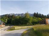
From Ljubljana, take the motorway past Salzburg towards Munich. At the Dreieck Inntal multi-level junction, take the A93 towards Innsbruck/Kufstein/Brenner. On your return to Austria, continue to exit 79 in the route Innsbruck-West. In Innsbruck, join the B174 road and continue to the 171 road junction, which you follow to the Hungerburg turn-off (Sonnenstrasse). Continue on the ascending road to the hamlet of Hungerburg, where you follow the signs for Hungerburgstation. Park in the large parking lot next to the funicular station; the parking fee is €6 for the whole day, which will be refunded if you buy a lift ticket.
Alternatively (to avoid buying an Austrian vignette): from central Slovenia, take the A2 motorway to one of the border crossings with Austria and continue to Lienz. Continue on the road 108 past Matreia and Osttirol and take the mountain expressway over the Felbertauern Pass (toll road, in 2020 the price was €11 for cars). In Mittersill, take the B165 and climb the narrower road to the Gerlos Pass (1628 m; fee €10). From there, descend to the point of the same name and continue to the junction with the B169. After about 20 km, join the B171 (direction Schwaz/Jenbach/Wörgl/Strass i. Z. ), which you follow all the way to Innsbruck and the turn-off for Hungerburg. From there, follow the above description.
Innsbruck can also be reached from northern Itali.
Path description:
From the funicular parking lot, at the first signpost, take route 216 towards mountain pasture Bodenstein. Continue along the forest road until the signs direct you to a pleasant path that winds across a meadow below the funicular, then heads uphill and crosses a forest slope. The path is sparsely marked in this part - although the route is obviously confirmed by the few direction signs - but it reveals a number of shortcuts that can also lead you astray. A little higher up, wooden fences and steps escort us as we cross the lane of the forest. We cross a grassy plain with enticing views of Innsbruck, and a little higher up we see the mountain road again. Here, continue to the right and, at the first major junction, take route 216, which turns sharp left into the forest. As the path becomes narrower and starts to climb moderately, we are also joined by the characteristic Austrian markings in the conscious colours of the national flag. The climb up the otherwise visually appealing forest slope is relatively short and soon the views open up as we ascend along a distinct ravine towards Bodenstein Alm. The latter is reached after about 20 minutes of further walking through pine trees and across a meadow.
At mountain pasture, where a pleasant alpine hut stands, follow the signs for route 216 towards the Nordkette and Hafelekarspitze cable car stations, which are directly ahead. The path becomes steeper but remains technically easy. After joining the trail from Seegrube below the Hafelekar summit slope, cross eastwards, cross the upper edge of the ravine (easy) with the help of a cable car (not difficult), where snow lies for a long time, and climb along the crawl fences in the cornices to the Nordkette cable car top station.
At the top of the funicular, turn right towards the nearby Hafelekarspitze summit, which is approached after less than ten minutes' walk along a comfortable and often well-traveled path.

Pictures:
 1
1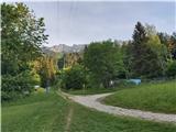 2
2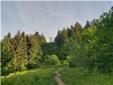 3
3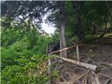 4
4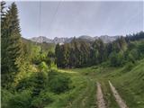 5
5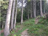 6
6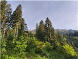 7
7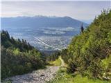 8
8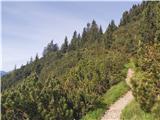 9
9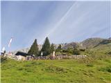 10
10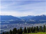 11
11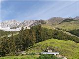 12
12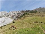 13
13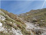 14
14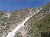 15
15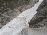 16
16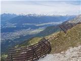 17
17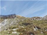 18
18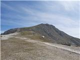 19
19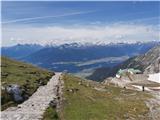 20
20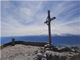 21
21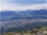 22
22
Discussion about the trail Hungerberg (parking lot at the station of funicular) - Hafelekarspitze (from Hungerberg on path 216)