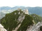
Gozd Martuljek - Rigljica (normal approach)
Starting point: Gozd Martuljek (750 m)
| Lat/Lon: | 46,4821°N 13,8378°E |
| |
Name of path: normal approach
Time of walking: 5 h
Difficulty: rock climbing ascent
Altitude difference: 1324 m
Altitude difference po putu: 1500 m
Map: Kranjska Gora 1:30.000
Recommended equipment (summer): helmet
Recommended equipment (winter): helmet, ice axe, crampons, lamp
Views: 11.782
 | 5 people like this post |
Access to the starting point:
From Mojstrana drive to Kranjska Gora or vice versa, but only as far as the village of Gozd-Martuljek, where you park in the parking lot near the bridge over the Sava Dolinka river (the parking lot is located behind the bridge, or in front if you are coming from Kranjska Gora).
Path description:
From GM, head towards Kurje Summit. In cirque below Rigljica, at the boulder marked PP, turn left along the scree to the ridge between Kurji vrh and Rigljica. Walking on the rubble can be very strenuous, so keep to the right side, which has a nice lane of dwarf pines. Without any major problems, we reach the ridge, and from there, the admittedly rare cairns indicate the way ahead. A barely visible path winds along the slopes above Pišenco, and sometimes the path also looks into the northern walls. The path as we approach the summit building soon leads us to a notch, where the leisurely hike is over.
The first wall is about 100 m high. Climb it straight ahead, or slightly to the right, following the obvious cleft (easy grade I), traverse right at the level for about 30 m and then bite into the second wall. This direction is also more to the right, and can be guided by the belly rock around which the route passes. Continue along the gully, where, higher up on a pine tree root, you will come across an anchorage for the descent on your return. From the root, climb slightly left and in a pleasant scramble (grade II) reach the crest of the headland. Follow the ridge to the left to reach the descent anchorage. From there, descend into a fallen gully for about 15 m. The last barrier, which is a detail of the tour, climbs steeply ahead. 20 metres of the gully have to be climbed before we can be clamped on a comfortable shelf in the anchorage. The hardest part can be bypassed on the right. On a very exposed ledge and around the edge on sloping slabs to the summit scramble (level II). But since we are now standing on a ledge, we have another wall ahead of us, which we climb diagonally to the right to a huge boulder where there is an anchorage for the descent. Now we have two options: the first is to go right around the edge and over the rock step to the summit scramble. The second option is for the brave: from the rock where you are standing, there is a distinct rockfall/rock towards the top. It is completely undercut in the left flank, so you have to climb right at once. The exposure is magnificent, the rock is crumbly. The cleft runs right to the top of the scrotum. We are standing on the Rigljica buttress, to get to the top, where there is a registration box, we have to descend to the collapsed crack, which we climb on the right. The main difficulties are over, there is still a stretch of scrotum to the top. Rigljica is considered by many to be the most difficult climb yet described in mountaineering and mountaineering guidebooks. Due to the jam, the detail reaches a good three. The detail is "packed". The world is opaque and orientation is difficult. The return route is along the route of ascent. The anchorages for the descent have been cleared and the auxiliary ropes replaced. The route is a UIAA level III/II mountaineering ascent. It is compulsory to be accompanied by an experienced mountaineer, preferably an alpinist.
Equipment is self-evident on this tour.
For consideration: the tour can also be connected with the nearby Rušica.
From Rigljica, descend back to a suitable point, where you head towards the large boulders. Pass the boulders to the Rušica cut and follow it over the slab to the top. Difficulties do not exceed level II. The route is extremely wild and I highly recommend it. To descend from the top of Rušica, return along the same route. Over the last post descend the rope-regulated descent.

Pictures:
 1
1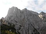 2
2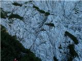 3
3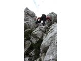 4
4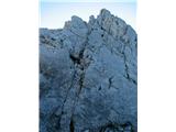 5
5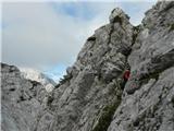 6
6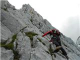 7
7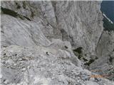 8
8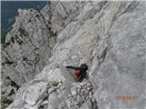 9
9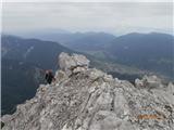 10
10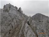 11
11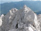 12
12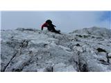 13
13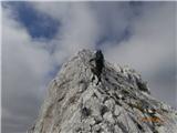 14
14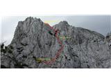 15
15 16
16
Discussion about the trail Gozd Martuljek - Rigljica (normal approach)
|
| Janez Seliškar8. 02. 2014 |
Vse manj je kotičkov, kjer občutimo tako povezanost z naravo. Komur znanje in psiha to dopuščata, zelo priporočam.
|
|
|
|
| malbreht6. 09. 2014 |
Pri vpisni knjigi manjka kuli,naj ga dobra duša ob naslednji turi vzame s seboj in pusti gor.
|
|
|
|
| 75'er6. 09. 2014 |
To ne bi smel biti problem, vsak planinec bi pisalo moral nositi s sabo, pa ga bo že riskiral.
|
|
|
|
| Jež si ti15. 12. 2016 |
Pozdravljeni,
kakšno opremo priporočate, glede na vaše izkušnje?
|
|
|
|
| turbo16. 12. 2016 |
Je take sorte gora, da tisti, ki se nanjo odpravi ne sprašuje po opremi 
|
|
|
|
| Janez Seliškar16. 12. 2016 |
Gre za alpinistični vzpon z nekaj spusti z vrvjo, torej se ve kaj rabimo.
Trenutno so zimske razmere, kar pomeni, tudi zimska oprema.
|
|
|
|
| andrej7816. 12. 2016 |
Res je mal hecno tole vprašanje...
|
|
|
|
| ben16. 12. 2016 |
Se ne oglašam ponavadi, ampak že v opisu je malo čudno omenjena oprema...samo čelada? Kljub alpinističnem vzponu? 
|
|
|
|
| ljubitelj gora16. 12. 2016 |
to pa mislim, da je problem spletne strani hribi.net. Na izbiro so:
čelada
komplet za samovarovanje
cepin
dereze
svetilka
|
|
|
|
| andrej7816. 12. 2016 |
Samovarovanje Riglica?
Potrebuješ vse za varovanje,pas,štrik(60m),kline,frende,reverso,komplete,gurtno,matičarke...no poleg zdej še zimske opreme...
|
|
|
|
| JusAvgustin17. 12. 2016 |
Tako ja, naredite znanost iz tega. Zahtevnost pove dovolj o opremi, kdor pa še vseeno ne ve kaj bi vzel s seboj kljub opisu pa naj ne sili gor in naj raje ostane doma!
|
|
|
|
| IgorZlodej17. 12. 2016 |
Samo oprema je bistveno premalo, potrebne so tudi zanje, izkušnje, nenazadnje psihična pripravljenost in pa soplezalec, če te zadnji trenutek ne pusti na cedilu.
|
|
|
|
| sAleska2. 08. 2018 |
40 metrska vrv je premalo za spuste?
|
|
|
|
| Viper2. 08. 2018 |
Močno priporočam 60 metrsko vrv. Bil sem na Rigljici v torek pa se mi zdi, da bi krajša vrv za spuste bila lahko problem.
|
|
|
|
| dprapr2. 08. 2018 |
A ni z Rigljice samo en spust, čez tisto trojko?
|
|
|
|
| Viper2. 08. 2018 |
Verjamem da je. Samo je priporočljivo se tudi drugje dol spustit. Zakaj bi se bilo treba tolk izpostavljat.
|
|
|
|
| JusAvgustin2. 08. 2018 |
100% podpiram Viperja... 2x30 ali 1x60. Potem bo sestop bistveno lažji. Seveda se gre lahko tudi brez, a zakaj bi iskal težave če so sidrišča?
|
|
|
|
| sAleska3. 08. 2018 |
Še enkrat vsem najlepša hvala. Res sem vesela, da človek tako hitro dobi zanesljive informacije iz prve roke.
|
|
|
|
| slavkoa29. 10. 2019 |
V nedeljo sva se z Mirjam lotila tega vrha, začela pri Jasni in polagoma ob zori osvojila Kurji vrh. Kljub manjšim zdravstvenim problemom se odpraviva po slabše vidni potki proti začetni škrbini. Prvo steno preplezava rahlo v desno in nato malo v levo do vršnjih nizkih borovcev. Tu se spustiva v grapo in zagledava še zadnji težji del vzpona-zajedo, ki naju pripelje do večje skale s sidriščem. Od tu pa po zajedi do skrotja in že sva na predvrhu. Najdeva tudi vpisno skrinjico, vpisati pa se nisva uspela saj je vpisna knjiga v zelo slabem stanju. Malo se še razgledava po grebenu proti Rušici, ki bo najin cilj skupaj z Vrhom nad Rudo ob prihodnjem obisku teh koncev. Prečudovito vreme nama omogoči še nekaj fotkanja nato pa se odpraviva nazaj po isti poti. Seveda sva uporabila vsa sidrišča za abzajle in se varno spustila po poti proti Kurjemu vrhu in do izhodišča pri Jasni. Tura je kar zahtevna, še posebej, ko se bova lotila preostalih treh vrhov s spustom s Frdamanih polic do Kačjega grabna. To pa prihodnje leto.
|
|
|