Gozd Martuljek - Mala Martuljška Ponca
Starting point: Gozd Martuljek (750 m)
| Lat/Lon: | 46,4821°N 13,8378°E |
| |
Time of walking: 6 h 30 min
Difficulty: very difficult pathless terrain
Altitude difference: 1751 m
Altitude difference po putu: 1800 m
Map: Kranjska Gora 1:30.000
Recommended equipment (summer): helmet, ice axe
Recommended equipment (winter): helmet, ice axe, crampons
Views: 19.986
 | 3 people like this post |
Access to the starting point:
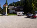
From Mojstrana drive to Kranjska Gora or vice versa, but only as far as the village of Gozd-Martuljek, where you park in the parking lot near the bridge over the Sava Dolinka river (the parking lot is located behind the bridge, or in front if you are coming from Kranjska Gora).
Path description:
From the parking lot, continue along the main road towards Kranjska Gora, but only to the point where the cycle path branches off to the left (there are also mountain signs at the start of the cycle path, which also direct you to the road). Follow the cycle path to the first crossroads, where you continue straight on to the dirt road (the cycle path turns right), which quickly leads you to the next crossroads.
Continue to the right and follow the road closed to traffic until you reach the TNP signpost. Further on, the path splits into two parts. Continue straight up the steep cart track, which climbs up the right-hand side of the Martuljška gorge. The cart track, which climbs mostly through the forest, leads us after 15 minutes to a beautiful viewpoint where a view of the valley opens up. The path then goes back into the forest and continues to climb. A little further on, the path from the waterfall joins us from the left, and a little further on, the path to the bivouac under Špikom branches off to the right. We continue in the direction of Ingot's hut. The way forward leads us to a crossroads, where we continue straight on, the path to the left leads to Ingot's hut to which is a two-minute walk.
The way forward is initially a steep climb but only for a while. The path then crosses a small well and climbs steeply on the other side. The steepness begins to give way to the path leads us to a crossroads, where we continue slightly right in the direction of the bivouac Za Akom (left Zgornji waterfall 10 minutes). The way forward is still some time steeply climbs, and then the path leads us to a more difficult part. First we cross a steep grassy slope with the help of a rope, and then, still with the help of fixed safety gear, we cross an exposed shelf (watch your head, slightly overhanging rock above us). The path continues to be guarded (the guards here are mainly due to the wet terrain), and then starts to climb steeply and, after a few minutes of further walking, leads us to the most difficult part. With the help of artificial steps and a rope, we cross a smooth and damp rock slab, and then cross a short, very steep wall, which is also well guarded (great care is needed because of the damp slope). The steepness of the slopes then eases and after a short climb, the still damp path leads us to the edge of the mighty gravels. Soon a marking on a rock directs us to the above-mentioned gravels, and right upwards leads the path towards the Za Akom bivouac, which is only a few minutes' steep climb away. When you reach the gravel, continue to the right where the numerous cairns also direct you. Keep to the right side of the stream as you walk along the wide channel of the torrent. Here we also have beautiful views of the northern walls of the Martulj Mountains where Široka Peč stands out. Below Široka Pečja, you can also see the landmark At the Three Larches. From the gravel paths, continue slightly to the left and climb briefly along the path through dwarf pines. The path leads to a slightly steeper torrent bed along which you then climb. The path here leads us up along the right side of the stream along an undistinguished ridge, past rare larch trees. This is followed by crossing a small stream and then climbing a scree slope, which leads us to steeper rocky slopes. From here, continue slightly to the right and cross the stream again on smooth rock slabs with a lot of sand. The slope here is quite steep and the sand on the rock slabs requires considerable caution. There is a short climb up a very crumbly steep slope, which is also dangerous for slipping, and then the path leads us to the lookout point Pri treh larchesnih.
From here, continue along the partly grassy ridge to the south, where you can see a characteristic boulder. Before the boulder, turn right, followed by a climb to the right under the scree of Oltar and Velika Martuljška Ponca. At the foot of Oltar, climb over a rock ledge. Then climb the scree and cross the chute that drops from under the Velika Martuljska Ponca. Finally, we reach the rock rib at the foot of the aforementioned Ponce. Here we climb some easy places and then descend into the gully that falls from the notch between Malo and Veliko Ponca. The gully, which initially has a slope of up to 30 degrees, then flattens out, with a slope of up to 45 degrees in the upper part just before the notch. From the stump, climb right along the ridge to the top. The rock is brittle. There is a register at the top. There is little space at the top.
Times.

We can extend the trip to the following destinations: Veliki Oltar
Pictures:
 1
1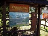 2
2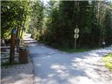 3
3 4
4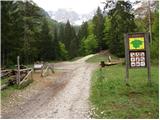 5
5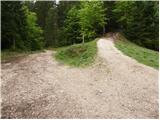 6
6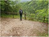 7
7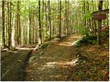 8
8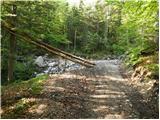 9
9 10
10 11
11 12
12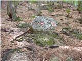 13
13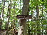 14
14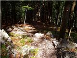 15
15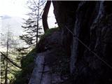 16
16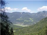 17
17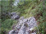 18
18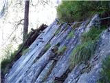 19
19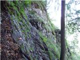 20
20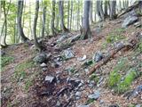 21
21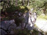 22
22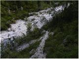 23
23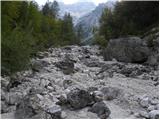 24
24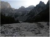 25
25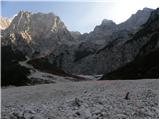 26
26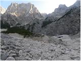 27
27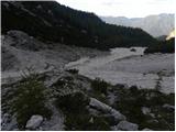 28
28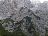 29
29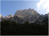 30
30 31
31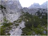 32
32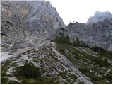 33
33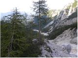 34
34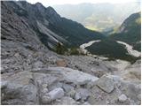 35
35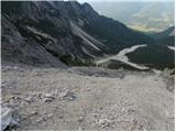 36
36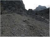 37
37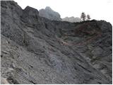 38
38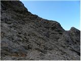 39
39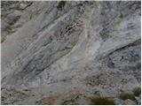 40
40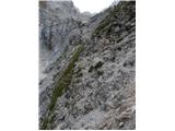 41
41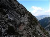 42
42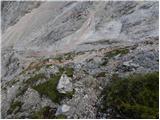 43
43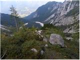 44
44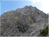 45
45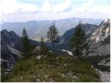 46
46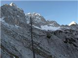 47
47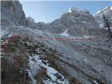 48
48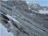 49
49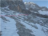 50
50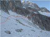 51
51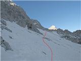 52
52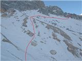 53
53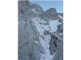 54
54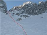 55
55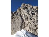 56
56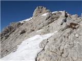 57
57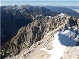 58
58
Discussion about the trail Gozd Martuljek - Mala Martuljška Ponca
|
| ljubitelj gora28. 07. 2012 |
Danes prehodil tole opisano pot, dereze, cepin ni potreben.
|
|
|
|
| ljubitelj gora28. 07. 2012 |
Pozabil dopisat, obstaja še ena pot, ki je lažja, vsaj krušljivosti, gre pa menda iz bivaka pod Špikom.
|
|
|
|
| AnzeKozjek16. 09. 2013 |
Lep pozdrav!
Nameravam v kratkem opraviti to turo in me zanima, ali je potrebno s sabo imeti vrv, ker sem slišal od kolega, da je nad sedlom desno zgoraj treba preplezati en bolj strm del... Bi bilo to potrebno? Hvala za odgovor! Lp
|
|
|
|
| lynx16. 09. 2013 |
Sam si boš pri vzponu z vrvjo težko pomagal in trenutno naj te bolj skrbita sneg in led. Težji odsek je čisto kratek (I) in vajenemu strmega poplezavanja ne bi smel povzročati težav. A ti spadaš v to kategorijo, pa ne morem vedeti, a če bi moral sklepati iz naloženih slik, potem nimaš kaj iskati na MMP. Meni se je zdel težavnejši pristop do Treh macesnov, a morda nismo zadeli idealnega vstopa.
|
|
|
|
| JusAvgustin17. 09. 2013 |
mislim, da si MMP v kopnih razmerah letos zamudil
|
|
|
|
| jedriličar17. 09. 2013 |
Poglej si moje slike na hribi.net http://www.hribi.net/trenutnerazmere.asp?slo=1&gorovjeid=1&id=2756&stran=3 Tam maš opisano pot čez kotle, pa na sliki 13 ti je del koji treba poplezati ... Pa tudi na vrhu tega dela (desno od lika u žutoj majici) je zabit en klin ki se lahko izkoristi za absajl če je sklisko za sestop (klin se lahko najde, je takoj na izstopu iz plezalnega dela stene). Pa lp in varno ....
|
|
|
|
| AnzeKozjek17. 09. 2013 |
lynx, ni ti treba sklepati iz slik, ker to so vtisi doživetij, ki sva jih naredila z mojo punco... imam kolega s katerim se lotim veliko zahtevnejših tur... mogoče ne glih alpinističnih... poleg tega nisem od včeraj in vem, da meni samemu nebi prišla prav vrv, varovala bi se pač s kolegom če je kje tak malo težji del.... Hvala vseeno! Lp
|
|
|
|
| andrejp20. 10. 2014 |
tole je pa res veliko šodra...ampak tako lepo. Včeraj seveda fantastičen dan, pod macesni sva gor ,,užgala,, svojo špuro po desni strani(nazaj po predvideni normalki po levi). Najtežje se nama je zdelo še prečenje dveh grap, kjer je izredno trd šodr in je težko narediti stopo. Tik pod sedlom še nekaj plezanja ob snegu, potem pa do vrha v sončku. Včeraj sama na vrhu, so bili pa vsi okoliški vrhovi obiskani. Super.
|
|
|
|
| gregah26. 07. 2021 13:52:17 |
Danes, 26.7.21 sem na srednjem Kotlu našel rdeč mobitel, apple. To je bilo že ven iz plezalnega dela čez žleb proti Na Pečeh. Info Grega, 041 226 886
|
|
|
|
| franc.rozman@adventure.si15. 08. 2022 19:57:28 |
V nedeljo 14.8.2022 smo bili trije na tej turi. Mimogrede smo se "pofočkali na B. III., - gneča spalnih vreč  . Po opremi sodeč se v teh koncih spet veliko pleza. Malo pred Tremi macesni je na levi strani rdeči steber v grapo poslal precejšen odlom, ki ga je v grapi treba prečit. V grapi pred samim vzponom na Tri macesne je še vedno veliko peska in drobirja, ni pa posebej težko izslediti poti, klin s pomožno vrvico je še vedno na mestu. Pri Treh macesnih /vpisna knjiga/ sta nas dohitela hitra alpinista, ki sta šla plezat v Mali oltar. Višje gori je pot v desno lepo sledljiva. Od sedelca, kjer se pogleda v Veliko dnino, v lepi plezariji /klin/ do vpisne knjige. Snega na poti ni bilo. Na samem vrhu smo se mi trije srečali z drugimi tremi. Za takšno goro kar veliko obiska bi rekel. Nazaj grede skozi Kotle. Možicev je dovolj. Tu in tam jih je treba intenzivneje iskati. Upam, da bodo komu te posodobljene informacije koristile. Srečno.
|
|
|
|
| matic416. 07. 2023 08:11:12 |
Pred kratkim je prišlo do manjšega vetroloma, naprej od odcepa za brunarico ,preden se pot strmeje vzpne in preči potok (za sliko 10). Drevesa so tam nametana ena čez drugo v radiju cca. 100m. Prehod je mogoč a težaven, bolje se je temu delu izognit po levi strani, potem pa strmo navzgor cca. 50m, ko se strmina unese, desno do markirane poti, naprej je pot normalno prehodna.
|
|
|