Gößgraben - Säuleck (Buderusweg)
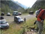
Starting point: Gößgraben (1600 m)
| Lat/Lon: | 46,9804°N 13,3351°E |
| |
Name of path: Buderusweg
Time of walking: 5 h 30 min
Difficulty: difficult marked way
Altitude difference: 1486 m
Altitude difference po putu: 1486 m
Map: Kompass 49 Nationalpark Hohe Tauern Sud 1:50000
Recommended equipment (summer): helmet
Recommended equipment (winter): helmet, ice axe, crampons
Views: 11.137
 | 3 people like this post |
Access to the starting point:
From the Karavanke Tunnel, follow the motorway towards Salzburg to the Gmund exit. Passing the centre of the medieval town, drive into the Malta valley to Koschach. The highest waterfall in Carinthia is on your right and a bridge crossing the River Malta is on your left. At the first crossroads, take the left-hand narrow road steeply up into the Gossgraben valley. You reach a large parking lot below the Goskarspeicher dam, at about 1600m. Some two thirds of the way the road is closed when the Giessener(hutte) hut is not in use.
Path description:
From the parking lot, follow the road below the dam to the closed ramp, then follow the road and marked shortcuts through the sparse forest to the Giessenerhutte hut (2202 m, 2 hours).
After the hut, follow the 533 (Buderusweg, towards Malnitzer Scharte) to the left, and straight ahead there is a path that later splits and leads either to Winterleitenkopf (2518 m, 45 minutes, easier) or to Hochalmspitze (3360 m, 4 hours from the hut, very difficult) or to Schneewinkelspitze (3016 m, 3 hours from the hut, medium difficulty). Cross a couple of streams flowing down from the Tripkees glacier. The trail, which is well marked at all times, leads across the slopes on huge blocks and slabs of granite, and is surfaced in places as steps or bridges. Caution is needed, however, because despite their large size and weight, these blocks are not all stable. Shortly afterwards, route 579, which leads to Tristenspitz and Reisseck, branches off to the left of our route. Below the Malník notch, we cross some snowfields, loking for the best passage, the route indicated by large red dots; there are a few metres of difficult scree straight up and then a rope-protected access right into the notch itself. In the stubble there is a memorial plaque to the path builders and a statue of the Virgin Mary. From the stubble at 2673 m we can see our destination, the Dosner lake below and the valley to Malnitz. From the stub it is possible to get directly to the 533A route, but due to the potholes we gain nothing. It is better to descend to a marked crossroads a few tens of metres below the stub and continue on the partially surfaced 533A below the extremely rugged Grosse Goessspitze. Here to, we cross some small snowfields (perhaps easier to negotiate with crampons). Join route 534 from the Artur-von-Schmid-Haus hut. There is a maze of paths on the upper slope, to the left of the marked path is one nicely cleared (August 2010) and more fot-friendly. Just below the summit, the Detmold Ridge Trail (535) joins. Some caution is needed on the top ridge, as the trail passes close to the precipitous edge. At the top there is a box with a registration book. From the top, you can see the cross, which is placed a few metres lower, at the exit of the western superferrata. The view is as befits a three-thousand-point summit. The hike is more strenuous than demanding, but it requires an absence of fear of the depths, a sure step, and some previous experience of high mountains. From the hut 3 and a half to 4 and a half hours.

Pictures:
 1
1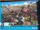 2
2 3
3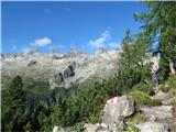 4
4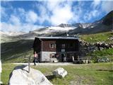 5
5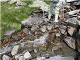 6
6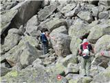 7
7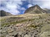 8
8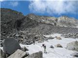 9
9 10
10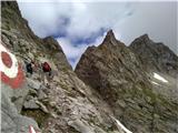 11
11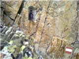 12
12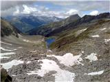 13
13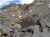 14
14 15
15 16
16 17
17 18
18 19
19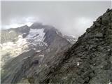 20
20 21
21
Discussion about the trail Gößgraben - Säuleck (Buderusweg)
|
| geppo20. 08. 2010 |
Lepa dolina..
Sem se lansko leto potepal tukaj, samo na drugi strani doline.
|
|
|
|
| geppo20. 08. 2010 |
Se opravičujem slov. napakam - žal nimam očal pri sebi!!
Lp
|
|
|
|
| VanSims4. 09. 2011 |
Zelo duhamorna pot. Še najbolj med majhnim jezercem pred Malniško škrbino, ko začnemo hoditi po skalah pa vse do priključka na normalko slabo uro pred vrhom. Najbrž je bil tudi to razlog, da na poti nisem videl žive duše.
Snežišč ni bilo nobenih, verjetno ta nekoliko olajšajo pot.
Sicer pa je treba paziti pri sestopu iz Malniške škrbine, da ne zgrešimo poti na vrh. Razcep(naravnost Arthur von Schmidt haus) ni takoj označen temveč šele nekaj deset metrov v smeri proti vrhu(desno) skrit med skalnimi bloki(slika 14).
|
|
|
|
| VanSims4. 09. 2011 |
Samo še pripomba, da kipec v Malniški škrbini ni marijin ampak kipec sv. Barbare.
|
|
|
|
| atoamac4. 09. 2011 |
Po čem ju razločiš, namreč Marijo in Barbaro?
|
|
|
|
| VanSims4. 09. 2011 |
Piše na podstavku kipca... 
|
|
|
|
| clopnamor13. 01. 2014 |
Zanima me povezovalna pot med Sauleckom in Hochalmspitze.Lp
|
|
|
|
| IgorZlodej13. 01. 2014 |
Poglej si mojo objavo pod Saüleck ali pa Mallnitzersharte, tam čez poteka pot.
|
|
|
|
| goginho218. 03. 2016 |
Žig vrha Säuleck je na vrhu, v koči ali ne obstaja ?
|
|
|