Dvor - Polhograjska Grmada
Starting point: Dvor (350 m)
| Lat/Lon: | 46,0659°N 14,3479°E |
| |
Time of walking: 2 h 10 min
Difficulty: easy marked way
Altitude difference: 548 m
Altitude difference po putu: 550 m
Map: Ljubljana - okolica 1:50.000
Recommended equipment (summer):
Recommended equipment (winter):
Views: 15.662
 | 2 people like this post |
Access to the starting point:
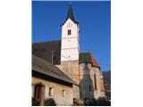
On 19. 12. 2007 I went to Polhograjska Grmada from the village DVOR. Let's look at the whole route by car from the route of Ljubljana, namely from the Ljubljana bypass. I went from the centre of Ljubljana along the Tržaška road and then turned right along the Viška road. I then take this road over the ring road (overpass) and continue through the villages Dobrova (2 km from the overpass over the ring road), Šujica (3 km), Razori (5 km), Hrastenice (7 km), Belica (9 km) and arrive at Dvor (10 km). It is a small village and there are no organised parking lots to be seen anywhere. So I parked near the fire house, which is towards the end of the village and walked back to the starting point. I passed a Gothic church dating from 1526 and came to a fountain where water is always flowing.
Path description:
At the fountain in the centre of the village of DVOR I saw a tree with a mountain signpost on it, which was supposed to lead me to Grmada. I walked up the hill and at the last house, where the asphalt road ends, I found that there was no real marker anywhere to give me information where to continue my journey. So I went directly up the hill first, where there was a visible footpath. However, after about 30 metres of walking uphill, I came to a cover, which probably encloses a water reservoir. From there there was no visible path. So I walked back down to the end of the tarmac road and decided to go south, along the dirt road leading to the newly built (currently unfinished) house. I passed it and again saw the sign pointing the way up the hill. From here, the steep uphill path continued, all the way to the hunting observation post. From the starting point to the hunting observation post, I walked for 35 minutes (including the time I unnecessarily veered off the path). From the hunting observation post onwards, the path is much less steep, all the way to the hunting lodge. Between the hunting observatory and the hunting lodge there is a crossroads of mountain trails for the directions Polhov Gradec, Dvor and Polhograjska Grmada. From the hunting observatory to the crossroads I walked for 10 minutes (45 minutes in total). I continued on the path and it took me another 5 minutes to reach the hunting lodge, where there is again a crossroads from where you can go left towards the Open Door Farm, straight on to Mala Grmada and right at the foot of the Mala Grmada to the top of the Polhograje Grmada (avoiding the steep climb up to Mala Grmada). I choose to go straight ahead and so walked alongside the hunting lodge steeply uphill. From the hunting lodge to the top of Mala Grmada took me an extra 15 minutes (1 hour 5 minutes in total). From here I continued to Polhograjska Grmada and descended a little way down to the saddle between Mala Grmada and Polhograjska Grmada and started the final climb. After 10 minutes (total 1 hour 15 minutes) I reached the top of Polhograjska Grmada. The trail is very poorly marked between Dvor and the hunting lodge and seems to have been abandoned by the responsible mountaineering association, but the trail is very well marked from the direction of the village Belica.
From here I had wonderful views of the mountains to the north and west (Porezen, Vogel, Triglav, Golica, Stol, Storžič, Grintovec, Velika planina). The stainless steel plate at the top, on which the directions of the sky and the peaks are written, helped me to find my way. The plaque was erected by PD Blagajana Polhov Gradec and PD Medvode. There is also a new stainless metal box with a stamp on the top, but I did not open it, so I do not know if the stamp and the book are also in it.
At the top I decided to return to the valley via the village Belica. So I descended steeply and after 10 minutes I came to a crossroads where there is a trail to the summit, to Belica and to the hunting lodge. The signposting at this junction is also critically poor, as there is only a signpost for the village of Belica, but not for the summit and the hunting lodge. I continued down the hill and eastwards, and after 45 minutes (55 minutes from the top) I arrived in the village Belica to the main road between Ljubljana and Polhovi Gradec. From here I returned along the main road to the village of Dvor, which is about 800 metres from Belica. After 10 minutes I returned to the starting point.
God luck.
My effective walking time: 2 hours and 10 minutes, from the starting point to the summit and back to the starting point.
Altitude of the starting point: approx. 350 metres
Altitude Polhograjska Grmada: 898 metres
Literature used: book 111 excursions in the Slovenian mountains and GPS device

We can extend the trip to the following destinations: Tošč
Pictures:
 1
1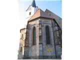 2
2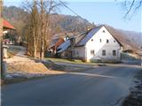 3
3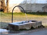 4
4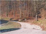 5
5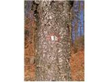 6
6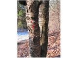 7
7 8
8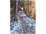 9
9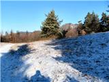 10
10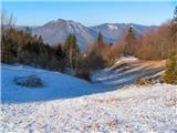 11
11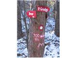 12
12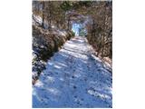 13
13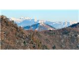 14
14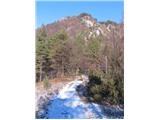 15
15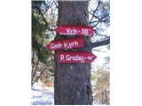 16
16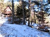 17
17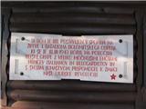 18
18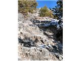 19
19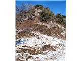 20
20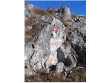 21
21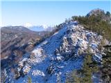 22
22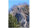 23
23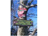 24
24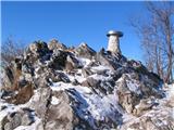 25
25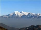 26
26 27
27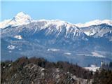 28
28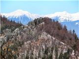 29
29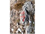 30
30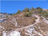 31
31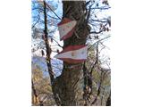 32
32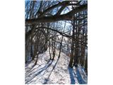 33
33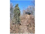 34
34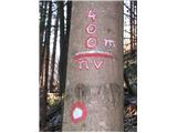 35
35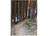 36
36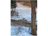 37
37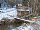 38
38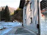 39
39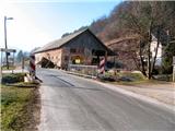 40
40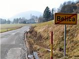 41
41 42
42 43
43
Discussion about the trail Dvor - Polhograjska Grmada
|
| matic415. 03. 2009 |
Sam sem to krožno pot opravil teden nazaj. Parkiral sem levo takoj za tablo Dvor. Parkirišče je vsaj za 20 avtomobilov, vendar je od okrog 11h že zasedeno. Vodno korito je obnovljeno in ni tako neugledno kot je na fotografiji. Na vrhu je treba za Belico iti kar naprej in navzdol ,potem so šele smerokazi. Za povprečnega planinca je čas hoje do vrha uro in pol. Sicer je pot tu opisana zelo natančno.
|
|
|
|
| Matt27. 04. 2009 |
Na razgledni plošči piše za višino Ojstrice 2530 m. Pravilno je 2350 m.
|
|
|
|
| Lisica7. 02. 2011 |
Tudi sama, ko sem pred leti prvič šla iz Dvora na PG Grmado sem imela probleme z manjkajočimi markacijami. Na to sem tudi opozorila ljudi, ki so nekaj urejali v koči pa so rekli, da je vse ok označeno oz da je tako shojeno, da ni problema najti. 
|
|
|
|
| Okmodko5. 09. 2011 |
Jaz pa hodim iz druzga dvora na Grmado in so lepše markacije. To je pa Dvor nad Šentvidom pri Ljubljani 
|
|
|
|
| Kozorog8. 09. 2011 |
Okmodko.... bodi tako prijazen pa napiši potek poti,če je možno? V kolikor bi bil tekst predolg pa mi opis prosim pošlji na ZS. Hvala!lp
|
|
|
|
| Okmodko9. 09. 2011 |
Če greš iz Guncelj proti Dvoru se takoj na začetku vasi Dvor na levo začne planinska pot. Tam so planinske table. Gledaš tisto na kateri piše Bormes. Potem se po merkacijah odpraviš po tej poti, prečkaš dvorski hrib z kapelico na vrhu (v gozdu), potem se spustiš prot gostilni Bormes. To je prva hiša na levo ko prideš iz gozda. Tam greš po cesti naprej, začne se asfalt, nato prideš na glavno cesto. Jo sam prečkaš, ker je na travniku nasprot uhojena potka proti Slavkovem domu.Od Slavkovga doma greš po cest naprej, po poti za Jeterbenk. Ko hodiš po poti za jeterbenk, se blizu vrha pri tabli za Katarino usmeriš po tej poti. Po tej poti prideš do Topola. Od tam pa mislim da veš prit na Grmado. Druga vrjanta pa je da greš na tisti omenjeni glavni cesti levo. In na ta prvem križišču po treh minutah pri kapelici spet po levi cesti. Po tej cesti pa pol ure hoje ko prideš v takšno samotno lepo dolinico brez hiš. Na konc te doline je ena hiša. Od nje pa sam gor po hribu in prideš na Topol.Z zemljevidom okolica Ljubljane mislim da ni teško najt poti. Hodi se pa kr dost no.
|
|
|
|
| Kozorog9. 09. 2011 |
Okmodko.... Hvala! bom preizkusil tvojo varianto, ker se mi zdi zelo zanimiva in slikovita!
|
|
|
|
| Okmodko10. 09. 2011 |
Čeprav...jaz grem iz Dvora zato ker nimam avta. Tja me pripelje avtobus. Če bi lahko,bi se raje že z avtom pripeljal do Bormesa. Ker ko hodiš nazaj,je tale Dvorski hrib res odveč,ko ga morš prečkat. Ker si že zmatran,pol morš pa še en hrib dat čez
|
|
|