Bohinjsko sedlo - Slatnik (northwestern peak) (direct way)
Starting point: Bohinjsko sedlo (1277 m)
| Lat/Lon: | 46,2409°N 14,01°E |
| |
Name of path: direct way
Time of walking: 1 h
Difficulty: easy unmarked way
Altitude difference: 332 m
Altitude difference po putu: 332 m
Map: Škofjeloško in Cerkljansko hribovje 1:50.000
Recommended equipment (summer):
Recommended equipment (winter): ice axe, crampons
Views: 8.761
 | 3 people like this post |
Access to the starting point:
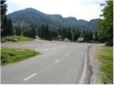
From the motorway Ljubljana - Jesenica take the exit Lesce and follow the road towards Bled and on to Bohinjska Bistrica. From Bohinjska Bistrica turn left towards Tolmin and Soriška mountain pasture. Follow this road to a large parking lot near the Soriška ski centre mountain pasture.
From Železniki go to Podbrdo or vice versa, but only as far as the signs for Soriška planina direct you to the ascending road. Follow this road to the large parking lot at the foot of the Soriška ski slope mountain pasture.
Path description:
From the parking lot at Bohinj saddle, follow the macadam road towards Litostrojska hut on Soriška mountain pasture. After less than 5 minutes of gentle ascent, you will reach the mountain hut from which you will have a view of the nearby grassy slopes of the surrounding peaks.
From the hut, continue along the marked trail in the direction of Šavnik, Cairn and Lajnar. After a walk of 10 paces, you reach a less visible crossroads where the path to Možic branches off slightly to the right (inscription on a tree, straight ahead Lajnar). Take the above-mentioned path, which continues to climb gently along the edge of the grassy slopes of the Soriška mountain pasture slope (mountain pasture). A little higher up, the marked path turns right and starts to climb steeply through lane of sparse forest and scrub. The path soon leaves the wods and leads into a small valley, at the edge of which you then climb up to an old military barracks (a barracks converted into a sheepfold, with a small shepherd's hut next to it).
From the barracks, we pass a small chapel and climb up an undistinguished ridge, where the path from Lajnar joins us on the left. Continue left (straight ahead towards Šavnik and Možic) along a grassy ridge with a view, which will take you to the top of Slatnik in less than 5 minutes of further walking.

Pictures:
 1
1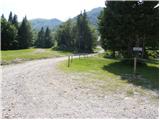 2
2 3
3 4
4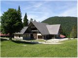 5
5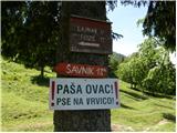 6
6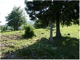 7
7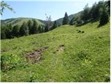 8
8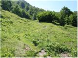 9
9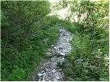 10
10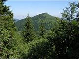 11
11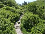 12
12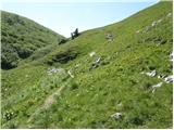 13
13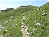 14
14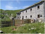 15
15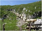 16
16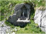 17
17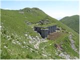 18
18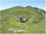 19
19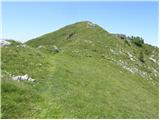 20
20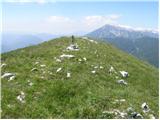 21
21
Discussion about the trail Bohinjsko sedlo - Slatnik (northwestern peak) (direct way)
|
| Majdag3. 02. 2023 07:38:48 |
S krpljami na Baško sedlo in Slatnik na 1. svečana dan. Cesta do Soriške planine je kopna in čudovita za peljat. Na obe strani so visoki snežni zameti. Snega na planini je dovolj, pešaki in krpljarji imajo svojo pot. Razgledi na sedlu so čudoviti, na vse strani so uhojene stezice, tudi do Možica. Prava zimska idila je na planini..  https://jelenkamenmajdag.blogspot.com/2023/02/potepanje-s-krpljami.html https://jelenkamenmajdag.blogspot.com/2023/02/potepanje-s-krpljami.html
|
|
|
|
| ropontika6. 02. 2023 07:30:40 |
Užitek je brati vaše opise poti in upam, da vas bomo še dolgo brali, čestitke. Ker je tam vas Bača, je verjetno Bačarsko sedlo zgoraj. Samo preverjam, brez zamere.
|
|
|
|
| Majdag6. 02. 2023 09:10:23 |
ropontika hvala, me veseli, če ste gledali tudi slike je na puščici v bregu nad Korom napisano Baško sedlo. Lahko bi bilo tudi Bačarsko, tega pa vem..
|
|
|
|
| franca6. 02. 2023 22:25:42 |
Sedlo se je imenovalo Vrh Bače. Zadnja leta se uveljavlja sedlo, podobno tudi Pavličevo sedlo namesto Pavličev vrh.
|
|
|
|
| ločanka7. 02. 2023 05:45:41 |
Vrh Bače je pa drugo, 1273 m in drugje. Na križišču poti, ki pod Slatnikom pripelje od Petrovega Brda in poti, ki pripelje iz Podbrda (sedlo med Koblo in Šavnikom). Tako kažejo zemljevidi in taki so tudi povsod opisi.
|
|
|